


Embedded maps, three levels of GIS integration
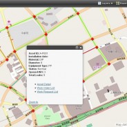
From its first release in 2011, bluebee® cloud naturally featured embedded maps, an integrated GIS (Geographical Information System), allowing users to display and manage spatial data related to facilities, equipment and networks, incidents and work done, as well as workers.
read moreMobiGIS, the GIS experts powering Siveco’s Geographical Maintenance Portal
MobiGIS is an IT engineering company promoting the use of Geographic Information Systems (GIS) technologies in public and private organisations.
read more